GIS-LiDAR Based Identification of Water Impoundment Areas in Greene County, Pennsylvania
Objectives
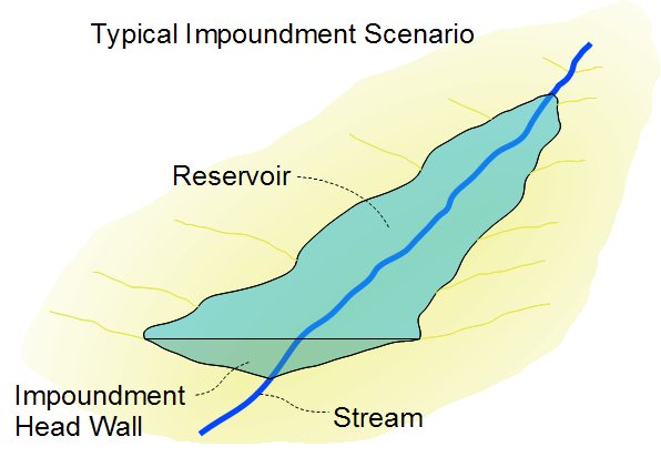
The purpose of this project was to identify small and intermittent streams in Greene County, Pennsylvania that could be impounded to capture yearly spring runoff and store it to serve as a source of water for Marcellus Shale drilling operations and for managed releases during periods of drought. Such impoundments, if large enough, could eventually provide an additional benefit functioning as recreational areas.
From a practical perspective this required achievement of the following concrete goals:
1. Creation of a new surface hydrography GIS line network including the small and intermittent streams required for this study. This was necessary because the current National Hydrography Dataset (NHD) hydrographic network, which represents the alternative data source, might not include streams small enough for this project.
2. Identification of sections along the newly created hydrographic lines satisfying a set of suitability criteria thus making them potentially appropriate locations for the construction of water impoundment structures. In general suitability criteria should include physical (drainage area, slope) as well as cultural factors (land use, land ownership). This study focused exclusively on the physical criteria with the understanding that it needs to be followed up by a study including cultural criteria in order to identify locations which could legitimately be considered as water impoundment targets for the purposes of this initiative.
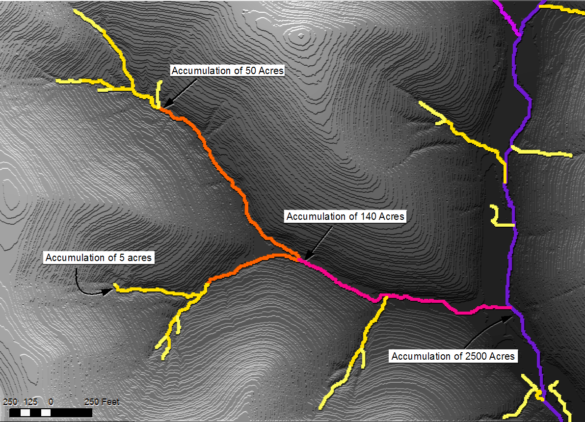
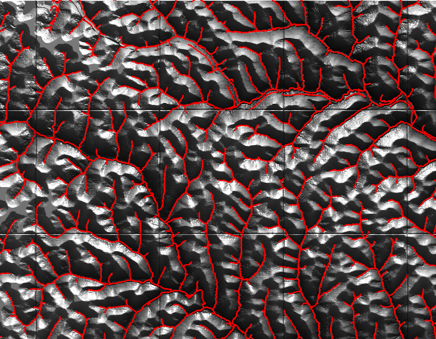
From a technical perspective this required the creation of a fine resolution digital drainage model suitable for extraction and classification of small scale and intermittent streams by means of automated GIS / Spatial analysis procedures. For the purposes of this project the digital drainage model consisted of two coincident raster surfaces which were derived from fine grained LiDAR based "bare earth" elevation data (developed by PAMAP project). The first surface consisted of a simple slope raster where every pixel records the slope of the terrain at its location. The second surface consisted of an "accumulation" raster, so called because it was created by an algorithm which assigns to every pixel a number equivalent to the sum of all pixels that would provide drainage to it.
Accumulation rasters, in particular, have properties that make them very useful for this project and for surface hydrology modeling in general. Natural drainage channels stand out as a set of pixels having accumulation values orders of magnitude larger than those corresponding to the surrounding terrain. Furthermore the accumulation values themselves, when multiplied times the size of a pixel yield the size of the watershed draining naturally at any point of the terrain surface. Size of watershed in turn is proportional to the total volume of suface drainage generated by an area.
Selection Criteria
As mentioned previously, physical criteria exclusively involve topographic and hydrologic considerations, which can be summarized as follows:
1. Drainage Area:
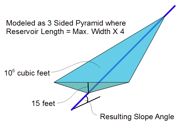
a. The stream sections under consideration should drain areas of a size between a minimum and a maximum threshold, judged to be enough to fill impoundment areas holding at least one million cubic feet in one year's time.
b. Regarding the minimum threshold area, it is important to point out that fluctuations in the use of water by gas producers, as well as in the amount of rainfall in any given season will have an effect on the water budget for these impoundment areas. If the average recharge rate is too low the impoundments may not serve their purpose adequately or dry up completely. If the average recharge rate is too high it will be necessary to build water control structures, such as spillways or weirs. In practice it may be necessary to select streams with a somewhat larger drainage area in order to insure that the desired volume is available on a consistent basis, thus requiring the construction of spillways regardless.
c. The maximum drainage area threshold is meant to exclude larger perennial streams which form part of the public water supply system and it may also help minimize the cost of constructing and maintaining water control structures.
d. In order to estimate the required drainage area a statistical approach was used to determine the expected drainage per unit area by analyzing United States Geological Survey (USGS) stream flow data gathered over a period of 30 years within 37 distinct watersheds scattered throughout this region.
2. Slope:
a. The stream sections under consideration should not be steeper than a specific slope value. This requirement is necessary for the following reasons:
i. In order to capture a set amount of water, an impoundment located in steep terrain would require a higher headwall or a deeper basin than an equivalent impoundment located in flat terrain. Since the depth of water held back at an impondment head wall is limited by government regulations to 15 feet before the impoundment is considered a bona fide dam, steeper terrains are less desireable. Basins in steeper terrain could be excavated upstream from the headwall in order to increase capacity, however these would assuredly be more expensive to build and maintain, and furthermore there may be a limit beyond which they are neither practical nor feasible.
ii. Slope for these purposes was measured along flow direction within the actual stream channels. The required slope was computed by assuming no excavation, and a 15 foot headwall bounding an idealized flattened wedge-like pyramidal (tetrahedral) volume of 1 million cubic feet having a length to width ratio of 4:1. These assumptions represent an initial educated guess based on a visual inspection of existing slopes in the area of study.
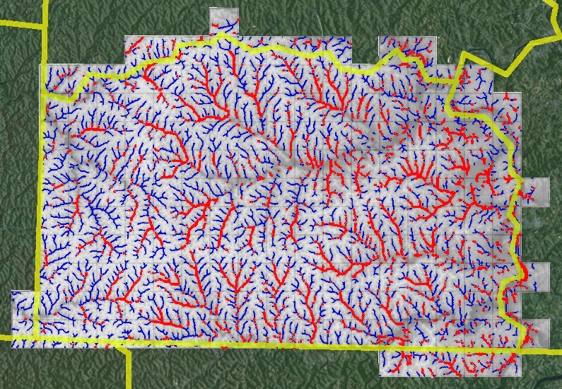
Stream segments were evaluated and classified in terms of drainage area and slope. Those that satisfied both criteria were included as potential locations for the construction of water impoundments.
Geo-processing Methodology
The methodology was automated by means of ArcGIS geo-processing tools implemented within python scripts. Results could be rapidly re-generated by inputting different sets of parameters, which could be fine-tuned as new information becomes available, furthermore allowing the evaluation of different scenarios and assumptions.
The sequence of specific geo-processing steps included the following:
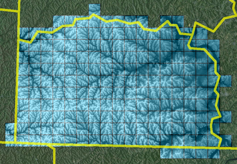
1. Creation of a seamless DEM (LIDAR derived) for the entire area of study.
2. Application of hydrological modeling procedures to generate new vector hydrography (including small and intermittent streams) from the seamless DEM covering the area of study.
3. Selection of specific vector stream segments based on the minimum watershed / accumulation area threshold extrapolated from USGS stream flow measurement statistics.
4. Development of a seamless slope surface from the seamless DEM.
5. Selection based on slope applied to vector stream segments previously selected based on minimum accumulation area threshold. The slopes applied represent a reasonable range slope angles calculated with the impoundment model outlined above. This procedure takes the stream segments and the slope surface as inputs and produces a new set of stream segments satisfying slope as well as accumulation threshold parameters.
.
Benefits and Future Use
As it stands, this methodology is ready for re-deployment with different sets of parameters at a substantially reduced cost. This simplifies the testing of different scenarios as well as the application within different geographic areas, displaying different physical realities. As a result this methodology is potentially very useful to jurisdictions facing challenges similar to Greene County.
An additional useful by-product of this methodology is the generation of new hydrography data layers having a much higher level of detail than the current federal government NHD dataset, often surpassing even locally available datasets.
Subsequent phases might include the development of further automation in order to make this methodology more user friendly, additional research to refine the input parameters and the inclusion of cultural features to the set of criteria employed for site selection.